


6,7 km | 9,3 km-effort
![Tocht Te voet Orlické Záhoří - [Z] Orlické Záhoří - Pěticestí - Photo](https://media.geolcdn.com/t/1900/400/d8ad28f5-7bee-40e9-8f00-8225c3f0e9b8.jpeg&format=pjpeg&maxdim=2)

Tous les sentiers balisés d’Europe GUIDE+


Gratisgps-wandelapplicatie
 SityTrail
IGN / Geografische instituten
SityTrail World
De wereld gaat voor u open
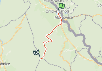
Tocht Te voet van 6,1 km beschikbaar op Noordoost, Královéhradecký kraj, Orlické Záhoří. Deze tocht wordt voorgesteld door SityTrail - itinéraires balisés pédestres.
Tocht aangemaakt door cz:KČT.
[Z] Orlické Záhoří - Pěticestí
![Tocht Te voet Orlické Záhoří - [Z] Orlické Záhoří - Pěticestí - Photo 1](https://media.geolcdn.com/t/2048/auto/ef147863-f58d-4a66-9673-ef6d69521d5c.jpeg&format=jpg&maxdim=0 "Tocht Te voet Orlické Záhoří - [Z] Orlické Záhoří - Pěticestí - Photo 1")
![Tocht Te voet Orlické Záhoří - [Z] Orlické Záhoří - Pěticestí - Photo 2](https://media.geolcdn.com/t/2048/auto/f29c636a-87a6-4764-9136-d3d05e26793a.jpeg&format=jpg&maxdim=0 "Tocht Te voet Orlické Záhoří - [Z] Orlické Záhoří - Pěticestí - Photo 2")
![Tocht Te voet Orlické Záhoří - [Z] Orlické Záhoří - Pěticestí - Photo 3](https://media.geolcdn.com/t/2048/auto/40a66706-9be2-4759-93c5-59635f9d4e1f.jpeg&format=jpg&maxdim=0 "Tocht Te voet Orlické Záhoří - [Z] Orlické Záhoří - Pěticestí - Photo 3")
![Tocht Te voet Orlické Záhoří - [Z] Orlické Záhoří - Pěticestí - Photo 4](https://media.geolcdn.com/t/2048/auto/a56f703f-1508-46c8-90cd-382d90701241.jpeg&format=jpg&maxdim=0 "Tocht Te voet Orlické Záhoří - [Z] Orlické Záhoří - Pěticestí - Photo 4")
![Tocht Te voet Orlické Záhoří - [Z] Orlické Záhoří - Pěticestí - Photo 5](https://media.geolcdn.com/t/2048/auto/f4534d49-da64-4762-b818-4fb390e5b524.jpeg&format=jpg&maxdim=0 "Tocht Te voet Orlické Záhoří - [Z] Orlické Záhoří - Pěticestí - Photo 5")
![Tocht Te voet Orlické Záhoří - [Z] Orlické Záhoří - Pěticestí - Photo 6](https://media.geolcdn.com/t/2048/auto/37b73808-e592-41dc-bb16-972b1a6e9798.jpeg&format=jpg&maxdim=0 "Tocht Te voet Orlické Záhoří - [Z] Orlické Záhoří - Pěticestí - Photo 6")
![Tocht Te voet Orlické Záhoří - [Z] Orlické Záhoří - Pěticestí - Photo 7](https://media.geolcdn.com/t/2048/auto/080e3f14-4250-4840-871c-3e59913e0d2a.jpeg&format=jpg&maxdim=0 "Tocht Te voet Orlické Záhoří - [Z] Orlické Záhoří - Pěticestí - Photo 7")
![Tocht Te voet Orlické Záhoří - [Z] Orlické Záhoří - Pěticestí - Photo 8](https://media.geolcdn.com/t/2048/auto/b89dcf8b-2b1a-4698-865a-d2ad371af220.jpeg&format=jpg&maxdim=0 "Tocht Te voet Orlické Záhoří - [Z] Orlické Záhoří - Pěticestí - Photo 8")
![Tocht Te voet Orlické Záhoří - [Z] Orlické Záhoří - Pěticestí - Photo 9](https://media.geolcdn.com/t/2048/auto/efc1a334-3a52-47e6-8843-deb352321e1b.jpeg&format=jpg&maxdim=0 "Tocht Te voet Orlické Záhoří - [Z] Orlické Záhoří - Pěticestí - Photo 9")
![Tocht Te voet Orlické Záhoří - [Z] Orlické Záhoří - Pěticestí - Photo 10](https://media.geolcdn.com/t/2048/auto/d8ad28f5-7bee-40e9-8f00-8225c3f0e9b8.jpeg&format=jpg&maxdim=0 "Tocht Te voet Orlické Záhoří - [Z] Orlické Záhoří - Pěticestí - Photo 10")
Te voet